- Acronimo
- ISOBatA
- Codice
- PNRA19_00121
- Anno
- 2019
- Area di ricerca
- Earth science
- Tematica specifica di ricerca
- Morphobathymetry
- Regione di interesse
- Southern Ocean, Ross Sea and Surrounding areas
- PI
- Daniela Accettella
- Istituzione PI
- Istituto Nazionale di Oceanografia e di Geofisica Sperimentale - OGS
- Sito web istituzionale
- https://isobata.ogs.it/pages/about.html
- Altre Istituzioni e soggetti coinvolti
- Università Milano Bicocca, IGAG CNR, INGV
- Consistenza del team ricerca
- Daniela Accettella (PI OGS) Alessandra Savini (UP Univ. Milano Bicocca) Marco Cuffaro (UP CNR-IGAG) Paolo Diviacco (UP OGS) Filippo Muccini (INGV)
- Stato progetto
- In corso
- Stazioni principali usate
- Nave
- Il progetto
Il progetto PNRA-ISOBatA si propone di sviluppare un approccio innovativo e sistematico all’acquisizione efficiente di dati batimetrici, sfruttando le acquisizioni lungo i transiti della R/V Laura Bassi nelle acque circostanti l’Antartide ovvero, lungo corridoi privilegiati al fine di massimizzare la copertura della mappa IBCSO (SCAR PROJECT). Tra gli scopi del progetto vi è la definizione di protocolli standard per l’acquisizione e l’elaborazione dei dati e la pubblicazione in un “Antarctic Data Repository” fruibile online. Infine, il progetto si propone di effettuare un focus su un’area particolarmente poco investigata e importante dal punto di vista scientifico come il settore del SW Pacifico in prossimità della giunzione tripla di Macquarie che si trova lungo la rotta di trasferimento da e per la Stazione Mario Zucchelli. Questo settore di litosfera oceanica registra l’interazione tra tre maggiori placche, la Antartica, la Pacifica e l’Australiana, e i dati batimetrici, insieme alle anomalie magnetiche, anch’esse registrate lungo la rotta, rappresentano il dato fondamentale per ricostruirne le complesse interazioni geodinamiche. ISOBATA rispetta le linee guida di SCAR, e Seabed 2030 è può rappresentare un contributo consistente alla mappatura delle acque Antartiche.
I partner ISOBatA sono: OGS, DISAT, IGAG-CNR, i compiti assegnati alle unità
OGS - Istituto Nazionale di Oceanografia e Geofisica Applicata si occupa di:
1. garantire il controllo di qualità ISOBatA (QC) sull'acquisizione, l'elaborazione e la memorizzazione di tutti i dati in corso raccolti seguendo i protocolli ISOBatA
2. Realizzazione di un "Data Storage Repository" con sito web basato su framework SNAP, un'infrastruttura web-based sviluppata da OGS dove i dati geofisici possono essere localizzati, interattivamente visualizzati in anteprima e accessibili (Diviacco & Busato, 2013) con visualizzatori di dati interattivi e struttura di metadati basata su standard O&M OGC (ISO/DIN 19156), (Diviacco et al., 2012) e servizi web OGC WMS e WFS.
3. Incentivare la collaborazione tra gruppi e navi operanti nel Mare di Ross al fine di massimizzare le acquisizioni batimetricheDISAT - Dipartimento di Scienze della Terra e dell'Ambiente dell'Università di Milano-Bicocca. Responsabile per l'applicazione di:
4. tecniche statistiche e computazionali (basate sul concetto di analisi geomorfologica, backscattering e Object-Based Image Analysis - OBIA) su DTM ottenuti e mappe per l’analisi dei modelli geomorfologici.
5. b) procedura automatizzata per la classificazione delle forme sottomarine potenzialmente responsabili delle emissioni di metano dal fondo marino (ad es. pockmarks, pingoes, vulcani di fango, fratture).
6. c) Interpretazione e classificazione delle caratteristiche geomorfiche rilevate sulla base di una nomenclatura e di una simbologia concordate a livello internazionaleIGAG-CNR - Istituto di geologia ambientale e geoingegneria Consiglio Nazionale delle Ricerche contribuirà a:
7. sviluppare modelli numerici 3/4D, compresi la reologia litosferica e il regime di stress regionale per spiegare la struttura Morfo-tettonica osservata della zona di frattura Emerald e il Punt Triplo Macquarie. IGAG si occuperà anche delle ricostruzioni cinematica e tettonica dell’area.
- Immagini
-
-
-
- Motivazione, importanza della ricerca
It is generally known that even if 71% of the earth's surface is covered by oceans, to date only a little portion of seabed has been mapped with an acceptable resolution (around 28%), in the Southern Ocean (the waters surrounding the Antarctic continent) the % of known seabed is even lower. Antarctic remote position and the difficulties of access related to the presence of sea ice for most of the year constitute an impediment to the exploration.
Nevertheless, bathymetric information is a key factor. In the polar field as:
Marine geology uses the morphobathymetric data to reconstruct underwater dynamic processes, depositional mechanisms of the bottom sediments and dynamics of the frozen platforms.
In oceanography, seabed morphology knowledge o improves the understanding of circulation and mixing systems between surface and bottom waters, contributing to the climate models setting up and the study of the global climate.
In marine biology, morphobathymetric data is suitable for fishing areas identification and for wildlife habitats mapping which is an important issue in an environment where the progressive expansion of ice-free areas, caused by global warming, stimulates biodiversity and competition between species.
A detailed bathymetry is also a crucial input for natural disasters and weather forecasting models.
The leading and comprehensive global-scale mapping project belongs to GEBCO (General Bathymetric Chart of the Oceans). GEBCO is an international non-profit organization that operates under the joint auspices of the Intergovernmental Oceanographic Commission - IOC of UNESCO and the International Hydrographic Organization - IHO.
In a join collaboration the Nippon Foundation and GEBCO have undertaken the Seabed 2030 initiative, which aims to collect all available bathymetric data acquired from any source to produce an accurate map (100m resolution) of the world ocean floor by 2030 making it available to humankind. The project is mainly founded on research institute and others institution voluntary contributions. It is managed by a committee made up of experts in the field of geosciences and hydrography from scientific and governmental institutions around the world. Seabed 2030 exploit the support of: a) four regional centres (Southern Oceans, South and West Pacific Oceans, Atlantic and Indian Oceans, Arctic and North Pacific Oceans), which take care of datasets collection, harmonization and maps diffusion, b) a global centre (Global Data Centre) which conveys all regional centres collected data and realizes the final product on global scale available on GoogleEarth. Finally, the IHO Data Centre, together with the other national centres, act as a long-term leading archive for digital bathymetry and, where possible, as suppliers of the original datasets.
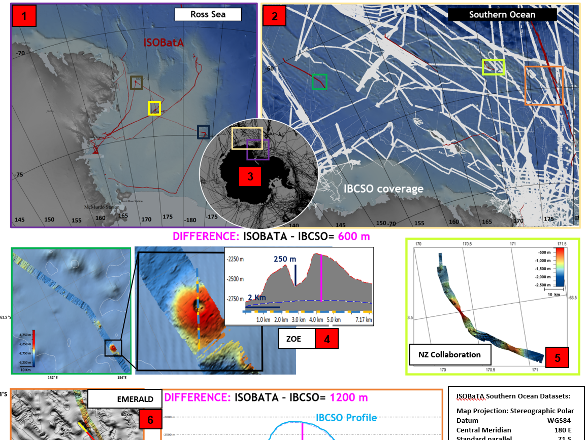
The Southern Ocean regional reference centre (Alfred Wegener Institute - AWI), is responsible for the IBSCO, International Bathymteric Chart of the Southern Ocean project. Launched in 2006, IBSCO project has been approved and is supported by the (Scientific Committee for Antarctic Research - SCAR). IBCSO aims to implement an advanced digital database containing bathymetric data available south of the 60 ° latitude S.Our proposal aims at defining an innovative and systematic approach that can exploit data sets collected within the Antarctic region and surrounding areas, during all Italian R/V Laura Bassi transit times: i) back and forth NZ and Antarctic waters, ii) between different approved PNRA projects of the R/V Laura Bassi. Data collection plan has been designed allowing the optimization of resources with an effective saving in the use of infrastructural support and logistic. Beside the systematic collection of bathymetric data during transit time the proposal aims at defining an high-standard acquisition protocol for data acquisition and processing that can be shared at international level ensuring at the same time the quality of acquired data. The project takes also into account the need of storing all acquired data and metadata in ad-hoc designed Antarctic Data Repository. A case study area (i.e., the Emerald Fracture Zone in the SW Pacific Ocean) is described in order to demonstrate the powerful potential of transit acquisition in remote areas normally affected by adverse weather conditions that make difficult to plan a survey.
ISOBatA fulfil SCAR, CONMAP, IHO and Seabed 2030 guidelines ensuring the Italian greatest contribution to the mapping of Antarctic waters and obtained IBCSO and Seabed2030 Support.
The project was approved by PNRA in June 2021 and funded in March 2022 and obtained 5 days (per years) as vessel speed reduction and rerouting during transits
- Obiettivi della proposta
ISOBATA Projects - Italian Southern Ocean Bathymetry from consistent exploitation of opportunistic seafloor datasets in Antarctic region and surrounding areas, introduces an innovative and systematic approach to exploit efficently bathymetric data sets collected in the Antartic region and surrounding areas during R/V Laura Bassi transits, homogenizing data with previlously collected. Data acquisition was designed to optimize the use of the infrastructural support and the logistic needs. Furthermore, the project aims at defining standard protocols and best practices for data acquisition and processing, ensuring acquired dataquality taking into account the need of storing acquired data and metadata in the Antarctic Data Repository.
The SW Pacific Ocean close to the Macquarie Triple Junction and Emerald is taken as main study area and will demonstrate the potential of transit acquisition in remote areas. This area is scientifically relevant to study the geodynamic evolution of 3 lithospheric plates: Antarctic, Pacific and Australian. Bathymetric data, together with magnetic anomalies, also collected along transits, could represent a powerful tool to understand a complex plate’s interaction. ISOBatA fulfil SCAR and Seabed 2030 guidelines ensuring the Italian contribution to the mapping of Antarctic waters.
ISOBatA Partners are OGS, DISAT, IGAG-CNR
OGS – National Institute of Oceanography and Applied Geophysics is in charge for:
1. ensuring ISOBatA quality control (QC) on acquisition, processing and storing of all underway data collected following ISOBatA protocols
2. Building of “Data Storage Repository” with website based on SNAP framework, a web-based infrastructure developed by OGS where geophysical data can be located, interactively previewed, and accessed (Diviacco & Busato, 2013) with interactive data viewers and metadata structure based on OGC standards O&M (ISO/DIN 19156), (Diviacco et al., 2012) and OGC WMS and WFS web services.
3. Fostering collaboration among group and vessels operating in Ross Sea and surrounding areas
DISAT – Department of Earth and Environmental Sciences University of Milano-Bicocca. In charge for the application of:
4. statistical and computational techniques (based on the concept of geomorphometric and backscattering analysis and Object-Based Image Analysis – OBIA) on obtained DTMs and backscattering maps, to reveal all geomorphic patterns.
5. b) automated procedure for submarine landform classification to detect submarine landforms in special mode that can be responsible of methane emissions from the seafloor (e.g., pockmarks, pingoes, mud volcanoes, fractures).
6. c) Interpretation and classification of geomorphic features detected based on internationally agreed nomenclature and symbology for submarine landforms
IGAG-CNR - Institute of Environmental Geology and Geoengineering - National Research Council of Italy. will contribute to:
7. develop 3/4D numerical models, including both lithospheric rheology and regional stress regime to explain the observed morpho-tectonic structure of the Emerald Fracture Zone. IGAG kinematic reconstructions will provide the development and growth of tectonic features.
- Attività svolta e risultati raggiunti
- Prodotti