- Acronym
- APP Antarctic Precipitation Properties
- Code
- PNRA14_00122
- Anno
- 2015
- Research area
- Atmospheric sciences
- Specific research topic
- Microphysics characterization of vertical profiles of precipitating clouds and surface precipitation
- Region of interest
- Terra Nova Bay
- PI
- Luca Baldini
- PI establishment
- National research Council, Institute of Atmospheric Science and Climate
- Institutional website
- https://www.isac.cnr.it/
- Other institutions and subjects involved
- Università di Bologna, Dipartimento di Fisica e Astronomia "Augusto Righi"
- Consistency of the research team
- The research team of the first two years was coordinated by Nicoletta Roberto, with operational units at the Rome unit of the CNR-ISAC (Luca Baldini, Elisa Adirosi, Stefano Dietrich) and at the Department of Physics and Astronomy of the University of Bologna (Rolando Rizzi, Federico Porcù, Tiziano Maestri, Alessandro Bracci). From 2020 the coordination of the project passed to Luca Baldini (CNR-ISAC) and the work team was extended with the research fellows Giacomo Roversi and Sabina Angeloni.
- Project status
- In progress
- Main stations used
- MZS
- The project
The knowledge of proetries and quantitative measurement of solid precipitation in Antarctica is of fundamental importance as precipitation represents the main input of Antarctic ice sheet mass, the variations of which have a direct and non-negligible effect on the average level of the oceans a global scale.
Despite this importance, the quantification and microphysical characterization of precipitation in Antarctica is still affected by significant uncertainties.
The quantification of precipitation over the entire Antarctic continent can be obtained from numerical weather-climate models or from satellite measurements. These approaches have the advantage of covering the entire continent thus providing an estimate of continental precipitation, but the accuracy of the estimate is not entirely adequate for many applications.
On the other hand, the quantification and microphysical characterization of precipitation can be obtained from ground-based instruments, such as pluviometers, disdrometers, or from remote sensing instruments such as meteorological radars. These instruments, although they cover a more restricted geographical area than satellite or model products, allow for much more reliable estimates and more significant microphysical characterizations.
In Antarctica, instrumentation for measuring precipitation from the ground is available and operational in various research stations. The project therefore proposes to install and use in a synergic way two co-located instruments for the study of precipitation: a laser disdrometer and a 24 GHz radar profiler, the latter used for profile measurements along the vertical at high resolution (35m of vertical resolution).
This configuration allows to have the first quote useful for radar measurements at just 100 meters above the ground, in order to make the most of the synergy with the disdrometer.APP intends to develop methods that exploit this synergy in order to obtain a correct quantification of the precipitation reaching the ground, a classification of the typology of the snow crystals and the identification of the vertical structure of the precipitating systems in the Terranova Bay. The APP results could be used for the calibration and validation of satellite and modeling products as well as for the validation of radar profilers on a satellite platform, such as the CPR (Cloud Precipitation Radar) of the NASA CloudSat mission and the ESA/JAXA EarthCARE mission which will be launched in 2024.
- Images
-
-
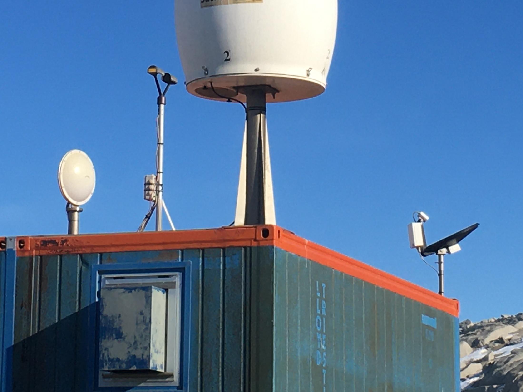
Disdrometro e Micro Rain Radar sul tetto del PAT presso Mario Zucchelli Station
-
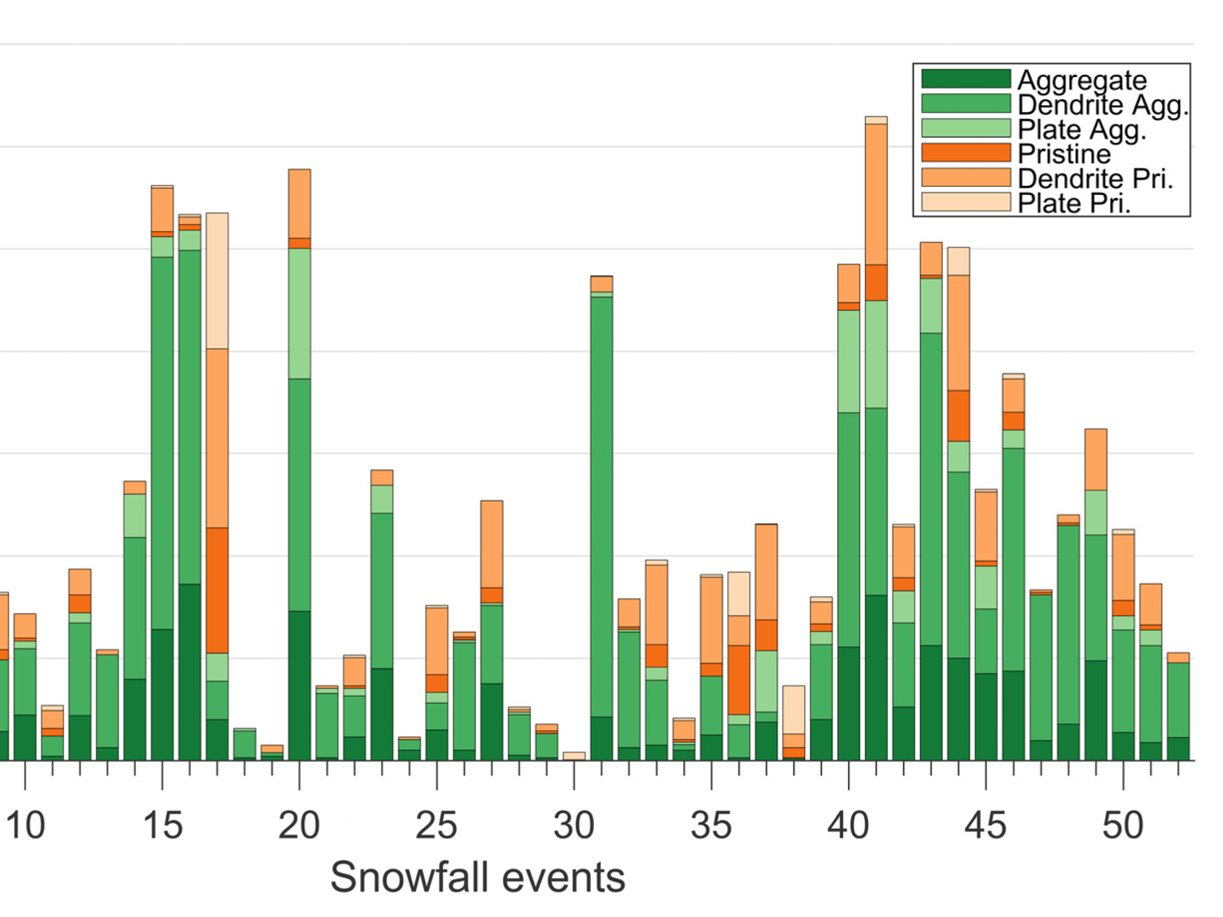
Classificazione cristalli di neve precipitanti presso MZS (Bracci et al., 2021)
-
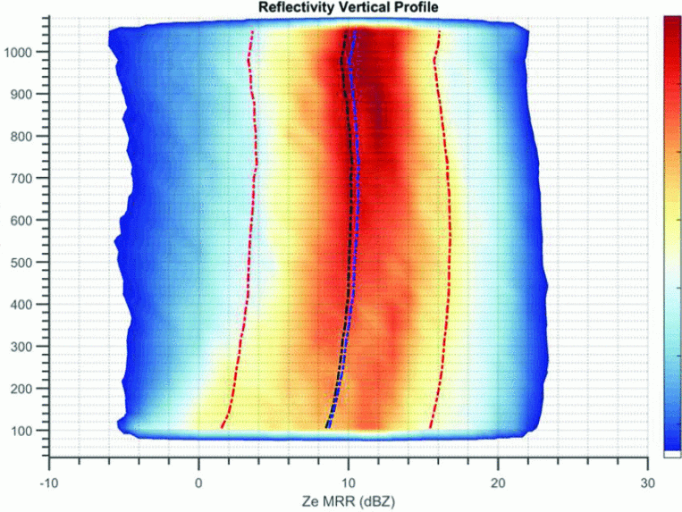
Occorrenza dei profili verticali radar (in termini di riflettività radar equivalente) presso MZS (Bracci et al.,2022)
-
-
- Motivation, importance of research
Estimating Antarctic precipitation with high accuracy would be key to sharpening understanding and ability to model phenomena such as changes in polar ice sheet mass and the Antarctic water balance that have direct effects on sea level trends and the global energy balance .
Quantifying rainfall on a vast, inaccessible, and poorly instrumented continent like Antarctica is a difficult challenge. The estimates obtained from satellite observations are attractive due to the ability to provide measurements on a continental scale. But despite advances in both satellite sensors and algorithms, the obtained precipitation estimates are characterized by poor accuracy. Even in situ measurements of snowfall are not without problems and difficulties, and in Antarctica they are available only at suitably instrumented stations.
The research of APP intends to develop and validate new methods and sensors for the quantitative measurement and characterization of precipitation in Antarctica by studying its microphysics. In fact, microphysical characterization is an essential tool to improve precipitation estimation algorithms both using ground measurements and using satellite platform measurements.
- Objectives of the proposal
The general objective of the proposal is to develop methods for the quantification and microphysical characterization of precipitation in Antarctica, both on the ground and along vertical profiles.
The methods are essentially based on the synergic use of a vertically pointing 24GHz radar (K band) (Micro Rain Radar, produced by Metek, Germany) and a Parsivel laser disdrometer (produced by OTT, Germany), also using measurements from other instruments already present at MZS such as the Eneide meteorological station, the ceilometer and weighing pluviometer. The combined use of this set of instruments will allow to characterize and study the properties of Antarctic precipitation, such as size, shape, falling velocity, density, particle size distribution (PSD), both at the ground and along the vertical. These instruments have been chosen for their reliability in unattended use, especially in the winter season when the station is unmanned.
The objectives of the first two years consist in the installation and configuration of the instruments and in the conduct of a preliminary analysis of the measurements to develop an ad hoc post-processing methodology which allows the classification of the precipitating crystals to be useful.
The two instruments will be installed next to each other, and the MRR will be configured so as to have a first useful altitude of the measurements at 100 meters above sea level, so as to minimize the discrepancies between the ground measurements obtained as much as possible from the disdrometer and the measurements obtained at low altitude from the radar.
The objectives of the second two-year period concern the improvement of the products for the quantification of precipitation and for the estimation of microphysics, and the comparison of these products with satellite measurements. It is also planned to increase the instrumentation with imaging sensors for the characterization of the shape of the precipitating particles. The products and data acquired will be indexed through the National Antarctic Data Center and will be made available on open access data repositories.
- Activities carried out and results achieved
In the first two years, the project installed the instrumentation and produced an algorithm for the classification of hydrometeors and for the quantification of precipitation based on the synergy between the MRR and the disdrometer.
Snowfall estimates are usually obtained by radar using empirical relationships developed from long-term measurements of radar equivalent reflectivity (Ze) and snowfall rate (SR). The synergy between the MRR and the disdrometer allowed the use of Ze-SR relationships as a function of the typology of the precipitating snow crystal. The disdrometer was able to provide information on particle size distribution 100 meters below the altitude of the first reliable MRR measurement.
The classification of hydrometeors is based on the best agreement between the equivalent reflectivity measured by MRR and the one derived from the PSD measured by a dysdrometer converted into equivalent reflectivity for six different types of particles. The snow crystals were classified into six different categories (aggregate, aggregate dendrite, aggregate plate, pristine, pristine dendrite, pristine plate).
The method was applied to the snow events of the Antarctic summer seasons of 2018-2019 and 2019-2020, for a total of 23,566 minutes of precipitation, of which 15.3% was recognized as composed of aggregates, 33.3% from dendrite aggregates, 7.3% from plate aggregates, 12.5% from pristine, 24% from pristine dendrite and 7.6% from pristine plates. By applying the appropriate Ze-SR relationship for each snow category, we estimated a total of 87 mm water equivalents, differing significantly from the total found by applying a unique Ze-SR relationship independent of the crystal type (method usually followed in the literature). Our estimates were also compared with a weighing rain gauge with an alter screen, obtaining a difference of only 3% in the periods analyzed (Bracci et al., 2021).
The same method was used to highlight the sublimation processes at low altitudes of Antarctic precipitation, the related implications on the radar estimation of snow precipitation on the ground and the difficulty of satellite estimates following these processes (Bracci et al., 2022). In the second two-year period, the synergies between satellite measurements and ground measurements were considered. Satellite measurements are crucial for providing continental-wide precipitation estimates, and this highlights the importance of validating satellite measurements with reliable measurements collected from Antarctic stations. The NASA CloudSat satellite, launched in 2006, has been equipped with a 94 GHz (W-band) Cloud Profiling Radar (CPR) that provides measurements of reflectivity profiles of clouds and precipitation. The next ESA/JAXA EarthCARE mission (launch expected by June 2024) will adopt a similar radar, but with Doppler capability for estimating vertical motions. The synergy between two instruments (laser disdrometer and MRR), available in several Antarctic stations, can be used to validate W-band radar measurements including Doppler estimates. A new validation methodology (K2W) was proposed to simulate 94 GHz reflectivity and Doppler measurements from Doppler spectra obtained from Micro Rain Radar. Evaluation of the proposed K2W methodology showed that Ze CloudSat profiles can be simulated with an average error of 0.2 dB. K2W manages to obtain the Doppler speed at 94 GHz which can be compared to what EarthCARE measures. The standard deviation of the simulated Doppler velocity was less than 0.2 m s−1 (Bracci et al., 2023).
A final aspect of the second two-year period concerns the use of imaging disdrometers. The expected advantage of such instruments is to obtain images of hydrometeors crossing a resolution volume defined by the depth of field and the width of the optical beam. The images obtained can be used for the purpose of a more precise classification of the hydrometeors and therefore of a more precise quantitative estimate of the precipitation. The instrument considered is the "3D Stereo Disdrometer" an off-the-shelf instrument by Theies CLima GmbH (Germany) which was tested in Casale Calore (AQ) (Montopoli et al., 2023) to be used in Antarctica by the XXXIX Expedition, again within the APP project.
- Products
- Journal papers
Montopoli, M., Bracci, A., Adirosi, E., Iarlori, M., Di Fabio, S., Lidori, R., Balotti, A., Baldini, L., & Rizi, V. (2023). Cloud and Precipitation Profiling Radars: The First Combined W- and K-Band Radar Profiler Measurements in Italy. Sensors, 23(12), 5524. https://doi.org/10.3390/s23125524
Bracci, A., Sato, K., Baldini, L., Porcù, F., & Okamoto, H. (2023). Development of a methodology for evaluating spaceborne W-band Doppler radar by combined use of Micro Rain Radar and a disdrometer in Antarctica. In Remote Sensing of Environment (Vol. 294, p. 113630). Elsevier BV. https://doi.org/10.1016/j.rse.2023.113630
Bracci, A., Baldini, L., Roberto, N., Adirosi, E., Montopoli, M., Scarchilli, C., Grigioni, P., Ciardini, V., Levizzani, V., & Porcù, F. (2021). Quantitative Precipitation Estimation over Antarctica Using Different Ze-SR Relationships Based on Snowfall Classification Combining Ground Observations. In Remote Sensing (Vol. 14, Issue 1, p. 82). MDPI AG. https://doi.org/10.3390/rs14010082
Scarchilli, C., Ciardini, V., Grigioni, P., Iaccarino, A., De Silvestri, L., Proposito, M., Dolci, S., Camporeale, G., Schioppo, R., Antonelli, A., Baldini, L., Roberto, N., Argentini, S., Bracci, A., & Frezzotti, M. (2020). Characterization of snowfall estimated by in situ and ground-based remote-sensing observations at Terra Nova Bay, Victoria Land, Antarctica. In Journal of Glaciology (Vol. 66, Issue 260, pp. 1006–1023). Cambridge University Press (CUP). https://doi.org/10.1017/jog.2020.70
Extended abstracts:
Bracci, A., Baldini, L., Roberto, N., Adirosi, E., Montopoli, M., Scarchilli, C., Grigioni, P., Ciardini, V., Levizzani, V., & Porcu, F. (2022). Evidence of sublimation in the vertical profiles of radar reflectivity and its impact on snowfall estimation at the ground at Mario Zucchelli Antarctic Station. In 2022 3rd URSI Atlantic and Asia Pacific Radio Science Meeting (AT-AP-RASC). 2022 3rd URSI Atlantic and Asia Pacific Radio Science Meeting (AT-AP-RASC). IEEE. https://doi.org/10.23919/at-ap-rasc54737.2022.9814266
Datasets:
Baldini Luca, Bracci Alessandro, & Roversi Giacomo. (2023). Particle size and velocity distributions from an OTT Parsivel optical disdrometer located at Mario Zucchelli Station, aggregated to 5min, monthly netCDF archive [Data set]. Zenodo. https://doi.org/10.5281/zenodo.7907497
Baldini Luca, Bracci Alessandro, & Roversi Giacomo. (2023). Vertically pointing doppler radar profiles (24 GHz Metek MRR-2) at Mario Zucchelli Station, aggregated to 5min, monthly netCDF archive [Data set]. Zenodo. https://doi.org/10.5281/zenodo.7907541