- Acronym
- ODYSSEA
- Code
- PNRA16_00205
- Anno
- 2017
- Research area
- Earth science
- Specific research topic
- Understanding of past and present ocean dynamics and glacial history
- Region of interest
- Scarpata continentale ad ovest dell'Hillary Canyon (Mare di Ross Orientale)
- Project website
- https://sites.google.com/view/pnra-odyssea/home
- PI
- Michele Rebesco
- PI establishment
- OGS
- Institutional website
- https://www.ogs.it/
- Other institutions and subjects involved
- University of Pisa, University of Parma, INGV, ISMAR
- Consistency of the research team
- 38 staff, including 26 researchers and technologists, 10 doctoral students and post-docs over the life of the project, two technicians, and a total of 15 males and 13 females
- Project status
- Completed
- Main stations used
- Nave
- The project
Relevance: Hillary Canyon is one of the few places in Antarctica where dense waters produced on the continental shelf flow down the continental slope and reach the ocean floor. But it is also an upwelling pathway for relatively warm waters flowing in the Current along the Antarctic Escarpment (ASC). The upwelling of these waters produces melting of the ice sheets at their base and triggers their instability, which is a major uncertainty in future sea-level projections.
Overall goal: To contribute to the understanding of past and present ocean dynamics and glacial history of this sector of Antarctica. In particular, to find evidence of past advances and retreats of the Antarctic Ice Sheet and their effects on deep water production and regime.
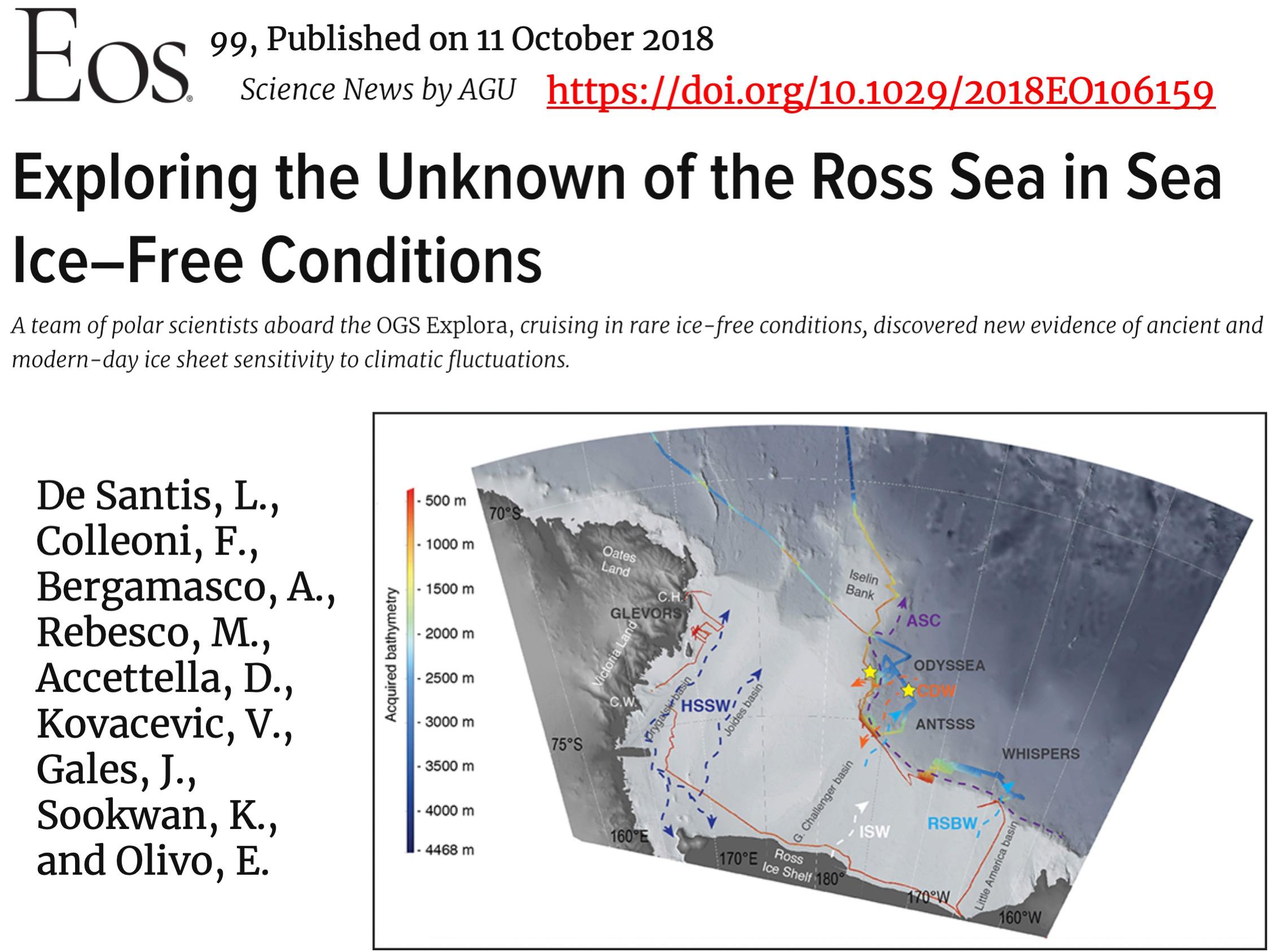
Data acquisition: 7 operational days on the OGS research vessel Explora as part of the 32nd Antarctic Campaign in 2017.
Products: morpho-bathymetric map, seismo-stratigraphic database, sediment samples and oceanographic data.
Publications:5 (plus 1 under review and 2 in preparation) refereed scientific articles in international journals, 16 conference proceedings, one book and one popular audiovisual.
Education:2 Bachelor's Theses; 1 Master's Thesis; 3 undergraduate and 2 postgraduate internships; 2 PhDs; 1 Fellowship.
Main results (details in publications):
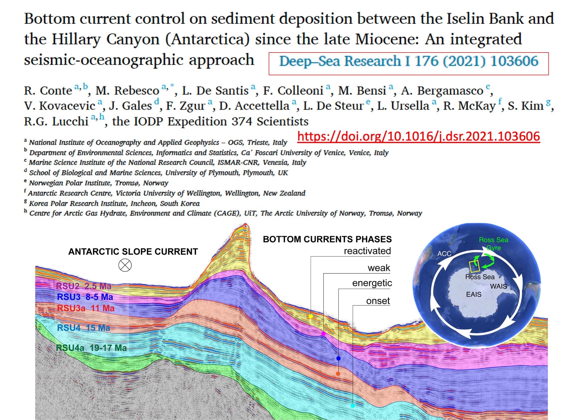
Geophysical data have enabled a better understanding of the role of dense shelf water in the development of Antarctic submarine canyon morphology and the identification of sedimentary bodies (drifts) at the base of the continental slope produced by the suspended loading of bottom currents related to dense shelf water flowing down Hillary Canyon.
Oceanographic data and numerical simulations enabled the identification of three main pathways of shelf water descent and analysis of the spatiotemporal variability of the general circulation of the Ross Sea.
Analyses on six cores a allowed the identification of 4 major climate phases from nearly 50,000 years ago, and comparison with advance and retreat of the Arctic Sea ice sheet, based on data and numerical simulations.
Analyses of the recent sediments allowed for the assessment of biodiversity, compatible with the extreme environmental characteristics present in the canyon, where strong bottom currents and the descent of cold water create an unstable habitat.
- Images
-
-
-
- Motivation, importance of research
A major uncertainty in future sea level projections is how the ice sheets will respond to global warming, particularly how much of Antarctica is losing ice mass across its large ice shelves. Warm ocean waters and the associated heat flux to the ice shelf, causing basal melting of Antarctic ice shelves, could reduce their restraining effect on ice flows (ice streams) and trigger instability. As is the case in the Arctic, heat transport by sea currents generates the progressive melting of sea ice and glaciers, which in turn has a substantial impact on local circulation. Consequently, studying how ice sheets and oceans have interacted in the past provides important constraints for improving numerical ice sheet models and sea level projections.
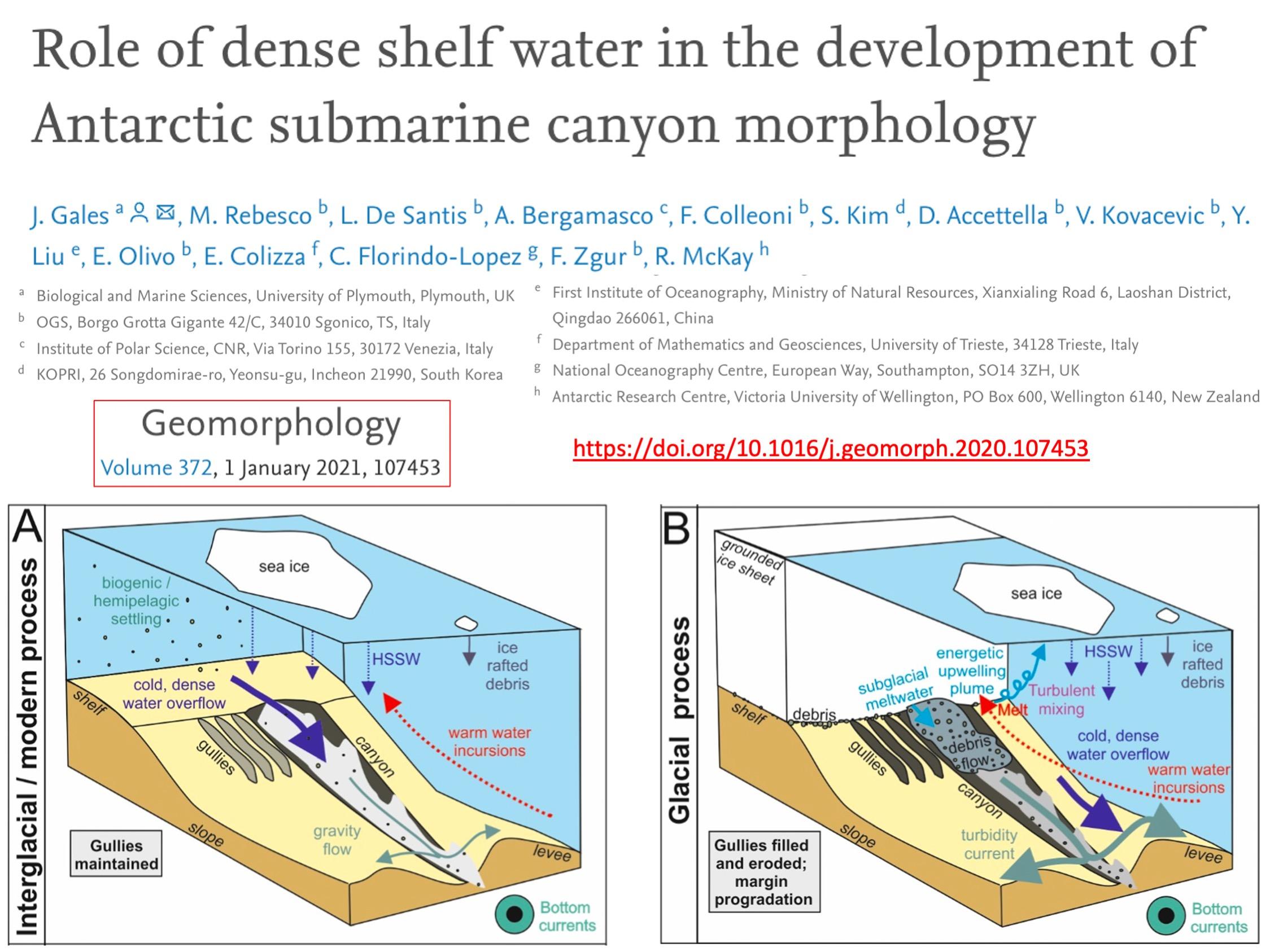
Bathymetric depressions on the continental shelf and deep incisions along the continental slope represent preferential pathways for exchange between dense shelf waters flowing along the continental slope and warm waters rising toward the continental shelf and the base of the ice shelf. Hillary Canyon, along the Ross Sea continental escarpment, forms a conduit for one of the largest outflows of dense waters in the Ross Sea, but it is also located at a focused area of warm water penetration to the Pennell and Glomar-Challenger basins. Consequently, it is an optimal location to reconstruct how ocean circulation has regulated past heat flow over the Antarctic continental shelf and past ice sheet advances/retreats.
The study area is located on the eastern margin of the Iselin Bank and on the continental rise west of Hillary Canyon, at about 74° S. Thick sedimentary deposits are preserved here and form the focus of this study. These have previously been interpreted as the product of the combined action of turbiditic and bottom currents flowing westward resulting in a mixed turbiditic and contouritic depositional system, as is the case in other sectors of the Antarctic continental margin. These depositional systems, which in some cases also include Mass Transport Deposits, constitute the continental uplift and offer an indirect but more continuous record of combined glacial and oceanic depositional activity. However, in the Ross Sea sector, the continental uplift is less explored than on the continental shelf, where numerous geophysical and geological data have been collected in order to reconstruct the advances/withdrawals of the ice sheet directly where it rested.
To explore the dominant glacial and oceanic processes acting in the area between Iselin Bank and Hillary Canyon, new seismic, morpho-bathymetric, and oceanographic data were collected during the 2017 R/V OGS Explora Antarctic Expedition. In 2018, Expedition 374 of the International Ocean Discovery Program (IODP) drilled a total of five sites as part of a transect between the outer continental shelf and the continental uplift to investigate past ocean-ice sheet interactions, and two of these sites were also located as a result of data collected in this project.
- Objectives of the proposal
Overall Goal: To contribute to the understanding of past and present ocean dynamics and glacial history of this sector of Antarctica. Specifically, to find evidence (in the geometry and distribution of stratigraphic sequences) of the advances and retreats of the West and East Antarctic Ice Sheet (WAIS and EAIS, respectively) in the Miocene-Pleistocene, and their effects on the production and regime of the Ross Sea Bottom Water (RSBW), with a chronological check of the Quaternary succession by means of sediment cores.
Specific objectives:
- To define the geometry and shape of sediment drifts and the volume of sediment involved through a specific high-resolution multichannel seismic survey.
- To define the acoustic character of the shallower sediment in order to relate sediment structures to current oceanographic conditions;
- Determine the composition and grain size of surface sediments by collecting a transect of gravity cores;
- Chronologically constrain seismic units through microfossil content, radiocarbon dating, and magnetostratigraphy of sediment cores;
- Obtain direct measurements of bottom water velocity to be used to quantify sediment load transport and to constrain the flow and transport model;
- Seek a relationship between sediment composition, microfossil content, grain size and hydrographic conditions;
- Produce a conceptual model of sediment circulation and transport based on current seafloor topography, also integrating the results of numerical simulations of Ross's current sea circulation at different scales.
- Activities carried out and results achieved
The acquisition campaign was carried out on the OGS research vessel Explora before the official start of the project (contract between CNR and OGS signed 10 months after the campaign), due to the timing imposed by the optimal climate window that allows data acquisition campaigns in Antarctica only during the austral summer and those imposed by ENEA as the logistics implementer. Inventory and consumable materials needed for the campaign were for this reason purchased through funds advanced directly by OGS. Among these were purchased:
- a sparker source for energizing simics data as a high-resolution but lower penetration alternative. Unfortunately, weather conditions and tight operating times did not allow its use;
- an SVP probe for multibeam data calibration, which was successfully deployed;
- a stereomicroscope for expeditious analysis, and indeed during the campaign we were able to analyze samples taken from the top and bottom of the first cores, allowing for better planning of subsequent cores;
- a PC for processing seismic data during the cruise, which allowed for preliminary analysis and submission of abstracts to the PAIS conference (due a few days after the end of the cruise).
With the data acquired in the OGS Explora campaign, they allowed for an understanding of the role of dense shelf water in the development of Antarctic submarine canyon morphology (see article Gales et al., 2020) and of the bottom current on sediment deposition between Iselin Bank and Hillary Canyon (see article Conte et al., submitted). The multibeam data, processed by OGS with Teledyne PDS Software and integrated with regional IBCSO data, provided a cartographic basis (see Map in Products 3.E) that allowed visualization of the location of the other data with respect to the bottom morphology. Seismic and sub-bottom data, processed at OGS, were loaded into a Kingdom project (see Database referred to in Products 3.F) that allowed their visualization and interpretation in an integrated manner.
Le 6 carote a gravità (11, 12 ,13, 14, 15 e 16) recuperate nel corso della campagna sono state archiviate presso il Museo dell’Antartide di Trieste e sottoposte a analisi non distruttive presso il Laboratorio congiunto (Università di Trieste e OGS) CoreLoggingLAB. Tali analisi, che hanno compreso le radiografie a raggi X e il logging in continuo di proprietà fisiche, hanno preceduto l’apertura delle carote stesse, la descrizione, il campionamento e le successive analisi condotte in vari laboratori. Purtroppo una serie di contrattempi logistici e amministrativi hanno ritardato queste analisi e la distribuzione dei fondi presso le diverse Unità di Ricerca. Questo è anche il motivo del conseguente ritardo nella scrittura di un articolo scientifico che utilizza i risultati di tali analisi (vedi articolo Morigi et al., in preparation).
Le sezioni archivio sono state quindi trasportate presso ISMAR (Bologna) e scansionate con un XRF core scanner Avaatech per la determinazione rapida e non distruttiva della composizione chimica del sedimento. Sono stati misurati circa 35 m di sedimento alla risoluzione verticale di 1 cm e 2.8 m ripetuti anche alla risoluzione verticale di 1 mm. Le carote sono state anche scansionate fotograficamente ad alta risoluzione (risoluzione verticale, 70 micron). L’acquisizione in digitale ha permesso sia la produzione di immagini che l’acquisizione di dati di colore secondo le 3 componenti base (RGB) e di luminosità. I profili verticali dei rapporti di alcuni elementi chiave (Zr/Rb, Ca/Ti, Mn/ti, Ba/Ti) e l’analisi delle immagini fotografiche hanno aiutato a definire, insieme a x-ray, suscettività magnetica, ecc. uno schema di correlazione fra le carote campionate. Avendo ricevuto i fondi a progetto ampiamente avviato, questi sono stati principalmente devoluti per acquistare un sistema di archiviazione dei dati relativamente alle simulazioni numeriche e un gruppo di continuità per la sicura conservazione dei dati, per pagare il laboratorio di misura XRF core scanner e per una serie di materiali di consumo utili alla corretta conservazione dei campioni per successive misure ed analisi (cestoni in acciaio porta carote, buste e rotoli tubo in PVC, ecc.).
To understand the spatiotemporal variability of the main water mass characteristics and general circulation of the Ross Sea, the ROMS model at 5 km resolution and 24 vertical levels, and boundary conditions were used at ISMAR (Venice): bathymetry from IBCSO, draft of the Ross sea ice Shelf from BEDMAP2, and atmospheric fluxes from Era-Interim data set. In the ODYSSEA study area, 3 main water masses interact strongly with each other: Antarctic surface water (AASW), Ross sea bottom water (RSBW), and circumpolar deep water (CDW). The AASW flows down to about 100-150 m depth. The RSBW (temperature <0 °C, salinity 34.60-34.70) sinks as a bottom current from the shelf to the escarpment increasing its velocity up to 25 cm/s between 1500 and 1900 m. Numerical simulation suggests that, although recurrent, RSBW cascading is not a continuous process. The CDW (temperature 0.50-1.50 °C, salinity 34.50-34.70) flows at intermediate depths (between 300 and 1000/1500 m). Thus, as with the sinking flow of the RSBW, CDW intrusion is episodic although often recurrent in the survey area. On the continental slope, turbidity gradually increases from about 1000 m toward the bottom, triggered by both ASC and cascading RSBW locally mixing with CDW. Three main pathways of shelf water emerge from the simulation as it sinks. Path 1, which comprises the largest volume, is connected to geostrophic adjustments, descending slowly due to bottom friction. It strongly retains its potential vorticity, which allows it to reach long distances from the spillover point near the shelf break. Path 2 is still more or less adjusted, but at deeper depths it becomes detached from the main geostrophic flow by barocline instability, descending down the left side of Hillary Canyon. Path 3 follows path 2, but is more variable and occurs when instabilities occur, allowing flow to reach the deeper part of the basin. Path 3 is related to intense cascading events that are much more episodic than the other two.
The results of the model simulations agree with the measurements collected in the oceanographic campaign, although these measurements represent only a snapshot of summer conditions. The main dynamic processes that characterize the entire Ross Sea, as well as the characteristics of the evolution of water masses, are consistent with the phenomenological model of this area. Furthermore, both the measurements collected during the campaign (especially the measurements with L-ADCP provided by Laura de Steur of the Norwegian Polar Institute, Tromsø) and the numerical simulations are in agreement with existing oceanographic datasets for this area. This gives us confidence to use the simulated and measured oceanic conditions to discuss the long-term interactions between major water masses and the geologic and geophysical analysis of the area.
Oceanographic data and numerical simulations have provided concordant results that the bottom currents at the base of the Iselin Bank escarpment are related to the dense waters produced on the Ross Sea continental shelf flowing through Hillary Canyon and from the Iselin Bank itself during cascading events, contributing their suspended load to the growth of sediment mounds on the continental uplift (see articles Gales et al., 2020 and Conte et al., submitted).
Paleomagnetic study of the resampled cores with U-channels analyzed with the cryogenic magnetometer of the INGV paleomagnetism laboratory provided a basis for paleoenvironmental interpretation and correlation for the collected sedimentary cores. Analysis of the magnetic parameters (variations in composition, concentration, and grain size of magnetic minerals in the investigated sedimentary sequences) shows that they correspond very well to the different lithostratigraphic units. Variations along the cores were therefore used to obtain information about the paleoenvironmental processes that occurred in the sedimentation basin. All typical rock magnetism parameters (magnetostratigraphy and the relative paleointhesity of the geomagnetic field recorded from the sediments) were used to improve the correlation between the cores previously based on lithologic features and XRF analysis, and dated by radiocarbon data (14C). Unfortunately, due to a problem with the instrument, some of the data (relative paleointensity) were not considered reliable and it was not possible to proceed with the analysis of a high-resolution chronology as planned, however, the identification of inclination minima, which can be correlated with known excursions of the Terrestrial Magnetic Field, were used to obtain tie points useful in defining the age of the cores.
Particle size and geochemical analyses of the sediment samples were conducted by the international partner at the First Institute of Oceanography, Qingdao, China, and detailed lithofacies study was carried out at OGS Trieste.
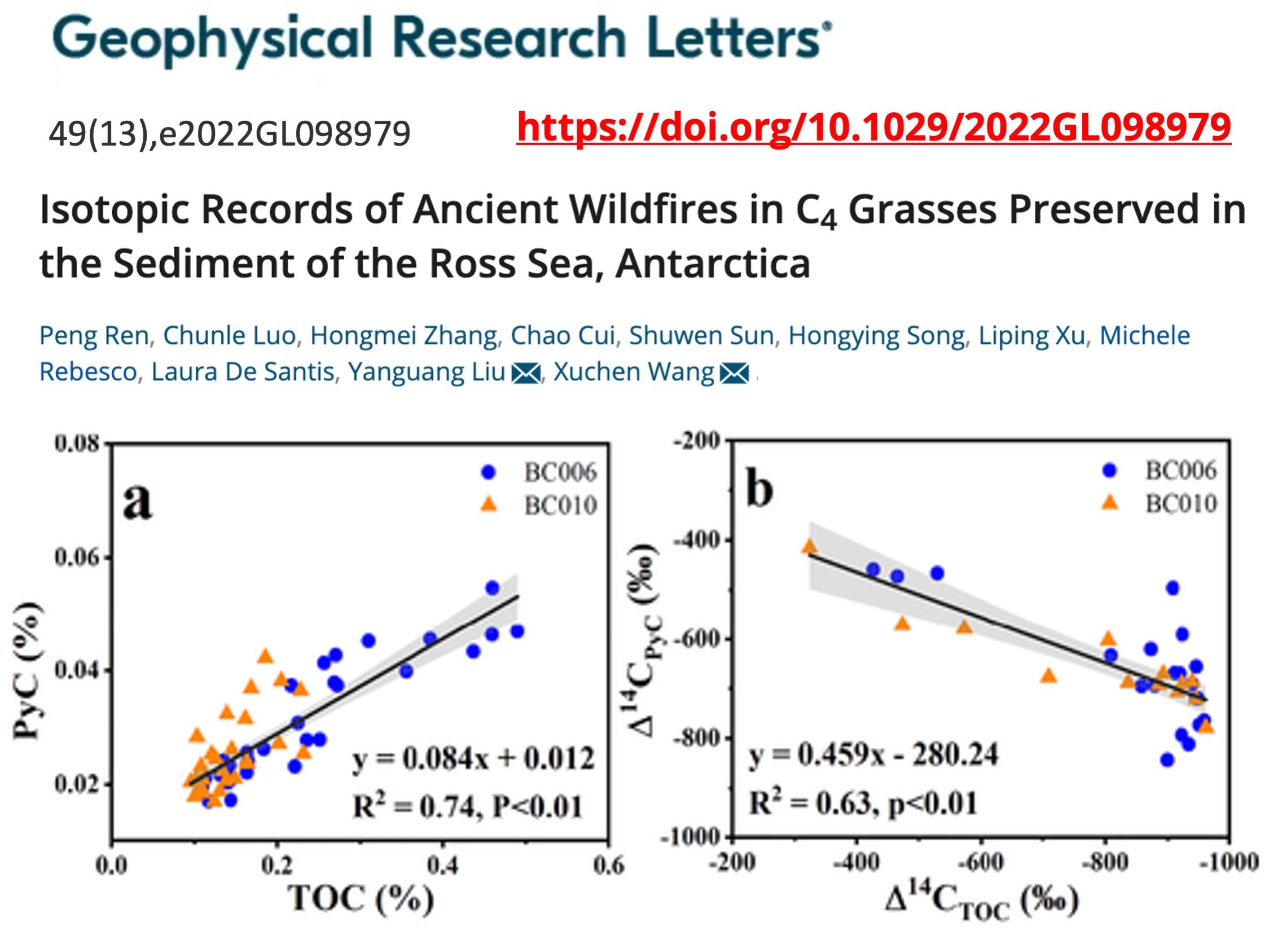
Micropaleontolgic (foraminifera, diatoms, calcareous nannofossils) and sedimentological (Ice Rafted Debris - IRD content) analyses of the six gravity cores taken on the escarpment were carried out at the Department of Earth Sciences, University of Pisa, and the University of Parma. The study of the microfossils and the content of the IRDs allowed: a) the correlation of the cores and subsequently the determination of an age model. This was done by integrating the results of paleomagnetism, XRF and geochemistry with the determination of lithofacies and biofacies; b) the reconstruction of paleoenvironments and paleocurrents, using the ecological significance of the different species of planktonic and benthic foraminifera, diatoms and calcareous nannofossils. For micropaleontological and IRD analyses, 336 sediment samples were taken. The results of these analyses identified 4 intervals related to different climatic phases (see article Morigi et al., in preparation). The oldest interval, from 42 Ka BP to 39 Ka BP, is associated with a cold period, corresponding to marine isotopic stage 3 (MIS 3) characterized by very harsh climatic conditions. The presence of strong bottom currents has been hypothesized, based on the presence of cross lamination in core 13-GC and 16-GC. A second interval, from 39 Ka BP to 27 Ka BP, is associated with a more temperate climatic phase, with increasing water temperatures and partial or complete absence of sea ice in the summer season. The third interval, from 27 Ka BP to 11 Ka BP, corresponds to the last glacial maximum, and is characterized by a very cold climate, evidenced by the presence in all cores from subglacial sediments. Finally, from 11 Ka BP to the present, the period corresponding to the Holocene, is characterized by relatively warm climatic conditions. This interval, represented only in the cores sampled at the base of the escarpment, is characterized by a benthic association typical of the present-day Antarctic deep environment. These periods were also defined by inter-hemispheric comparison with the reconstruction of the post-LGM retreat of the Storfjorden ice stream based on data and numerical simulations.
The three box-corers sampled during the oceanographic campaign of the ODYSSEA project, were analyzed for their microfaunal content. Although the study of modern faunal components was not one of the objectives of the ODYSSEA project, the collection of surprisingly rich samples in deep corals allowed the biodiversity assessment of epifaunal benthic foraminiferal associations to be obtained. In particular, a study was carried out on living benthic foraminifera that live attached to hard substrates represented by hydrocorals, shells and pebbles, along with those that colonize the water-sediment interface, and which are most studied, with the aim of characterizing the epibenthic component. As a general result we have a dominance of agglutinating species for both hard substrates and surface sediment. The taxonomic composition also reveals the peculiarity of the habitat with the dominance of both monothalamic and polyhalamic agglutinating component over the biocalcifying one. This distribution can be related to waters defined as corrosive with an acid pH that therefore does not allow biomineralization of calcareous species. These benthic foraminiferal associations could be shaped by the extreme environmental characteristics present in the canyon, where strong bottom currents and surface cascading phenomena, in an oligotrophic environment, create an unstable habitat.
- Products
Gales, J., Rebesco, M., De Santis, L., Bergamasco, A., Colleoni, F., Kim, S., Accettella, D., Kovacevic, V., Liu, Y., Olivo, E., Colizza, E., Florindo-Lopez, C., Zgur, F., McKay, R., 2021. Role of dense shelf water in the development of Antarctic submarine canyon morphology. Geomorphology, 372, art. no. 107453.
Conte, R., Rebesco, M., De Santis, L., Colleoni, F., Bensi, M., Bergamasco, A., Kovacevic, V., Gales, J., Zgur, F., Accettella, D., De Steur, L., Ursella, L., McKay, R., Kim, S., and the IODP Expedition 374 Scientists, Bottom current control on sediment deposition between the Iselin Bank and the Hillary Canyon (Antarctica) since the late Miocene: an integrated seismic- oceanographic approach. Submitted to Deep-Sea Research Part I: Oceanographic Research Papers 176, art. no. 103606.
Dorschel, B., Hehemann, L., Viquerat, S., Warnke, F., Dreutter, S., Tenberge, Y.S., Accettella, D., An, L., Barrios, F., Bazhenova, E., Black, J., Bohoyo, F., Davey, C., De Santis, L., Dotti, C.E., Fremand, A.C., Fretwell, P.T., Gales, J.A., Gao, J., Gasperini, L., Greenbaum, J.S., Jencks, J.H., Hogan, K., Hong, J.K., Jakobsson, M., Jensen, L., Kool, J., Larin, S., Larter, R.D., Leitchenkov, G., Loubrieu, B., Mackay, K., Mayer, L., Millan, R., Morlighem, M., Navidad, F., Nitsche, F.O., Nogi, Y., Pertuisot, C., Post, A.L., Pritchard, H.D., Purser, A., Rebesco, M., Rignot, E., Roberts, J.L., Rovere, M., Ryzhov, I., Sauli, C., Schmitt, T., Silvano, A., Smith, J., Snaith, H., Tate, A.J., Tinto, K., Vandenbossche, P., Weatherall, P., Wintersteller, P., Yang, C., Zhang, T., Arndt, J.E. (2022) The International Bathymetric Chart of the Southern Ocean Version 2. Scientific Data, 9 (1), art. no. 275.
Ren, P., Luo, C., Zhang, H., Cui, C., Sun, S., Song, H., Xu, L., Rebesco, M., De Santis, L., Liu, Y., Wang, X. (2022) Isotopic Records of Ancient Wildfires in C4 Grasses Preserved in the Sediment of the Ross Sea, Antarctica. Geophysical Research Letters, 49 (13), art. no. e2022GL098979, .
Cui, C., Tang, Z., Rebesco, M., Desantis, L., Li, C., Wang, X., Sun, S., Liu, Y. (2021) Sedimentary records of enhanced deep ventilation during the last deglaciation in the ross sea, Southern Ocean. Quaternary Sciences, 41 (3), art. no. 1001-7410(2021)03-678-13, pp. 678-690. Cited 1 time.
Gales J., McKay R., De Santis L., Rebesco M., Laberg J.S., Harwood D. Leckie R.M., Patterson M., King M., Lucchi R.G., Kim S., Kim S., Kulhanek D., Shevenell A., Dodd J., Seidenstein J. & IODP Expedition 374 Scientists, in revision, Climate-controlled submarine landslides on the Antarctic margin, Nature Communications.
Morigi et al., microfossil analyses of ODYSSEA sedimentary cores, in preparation.
Lucchi et al., sedimentologic analyses of ODYSSEA sedimentary cores, in preparation.
+ 16 Proceedings di convegni.
Audiovisivo "Antartide 360" (https://www.youtube.com/watch?v=oTiEYzUfI4g), presentato per la prima volta al Past Antarctic Ice Sheet Dynamics (PAIS) Conference September 10-15th 2017, Trieste da Associazione Explora (https://associazioneexplora.com/)
Mazzoli E., 2018. Capitolo 2.14. Dopo 10 anni, con la OGS Explora nuovamente in Antartide. In: Mazzoli E., Trieste fra i ghiacci, Edizione 2018, pp. 316. Luglio Editore, ISBN 978-88-96940-70-9