- Acronym
- DEFROST
- Code
- PNRA14_00068
- Anno
- 2016
- Research area
- Marine science
- Specific research topic
- Temporal and spatial variability of deep currents in the southwest area off Svalbard
- Region of interest
- ARTICO, Eastern Fram Strait, Svalbard Islands
- PI
- Manuel Bensi
- PI establishment
- National Institute of Oceanography and Experimental Geophysics, OGS
- Institutional website
- https://www.ogs.it
- Other institutions and subjects involved
- CNR (ISP), CNR (ISMAR)
- Consistency of the research team
- Acronym: PNRA14_00068-UR.1 Responsible: Kovacevic Composition: Laura Ursella, Davide Deponte, Paolo Mansutti, Vanessa Cardin, Martina Kralj (2017 on maternity leave), Matteo Bazzaro, Manuel Bensi Acronym: PNRA14_00068-UR.2 Responsible: Rebesco Composition: Leonardo Rui Acronym: PNRA14_00068-UR.3 Responsible: Miserocchi Composition: Alessandra D'Angelo, Stefano Aliani, Leonardo Langone
- Project status
- Completed
- Main stations used
- Basi Straniere
- The project
The purpose of the DEFROST (DEep Flow Regime Off SpiTsbergen) research project was to investigate the temporal and spatial variability of deep flow in the southwestern area off Svalbard, with a focus on near-bottom currents and their physical and biogeochemical properties. In-situ measurements were mainly conducted using oceanographic moorings, positioned at depths between 1000 and 1100 m. These moorings were equipped with current meters (ADCP, RCMs) and temperature, salinity, dissolved oxygen sensors (SBE37, SBE16) and sedimentation traps (McLane). The decision to use oceanographic mooring is motivated by the fact that the most energetic processes, which are generated by dense water formation on the continental shelf and are able to reshape the seafloor and form conturcts, occur mainly in late winter and early spring, when surveys by research vessels are difficult to achieve due to adverse environmental conditions. In addition, winds and ocean cooling change with winter weather conditions, thus affecting the volume and density of dense water plumes, and thus cascading currents along the slope west of Svalbard. To study the variability of these phenomena from year to year, continuous measurements, possibly extended over the years, are needed. DEFROST has brought together a multidisciplinary team of oceanographers and geologists to study the variability of thermohaline properties, sedimentary processes, and seismic data in order to assess the link between the current shape of the seafloor, deep-sea flow, and cascading plumes of dense water. This scientific activity follows previous international initiatives including: the EUROFLEETS2-PREPARED (Present and PAst flow REgime on contourite Drifts west of Spitsbergen) project, whose research expedition was carried out in June 2014 (RV G.O. Sars), and two subsequent oceanographic campaigns carried out in the same region in June and September 2015, with the R/V Helmer Hansen (HH cruise, Uni Tromsø, Norway) and R/V OGS-Explora (EXPLORA cruise, OGS, Italy), respectively.
- Images
-
-
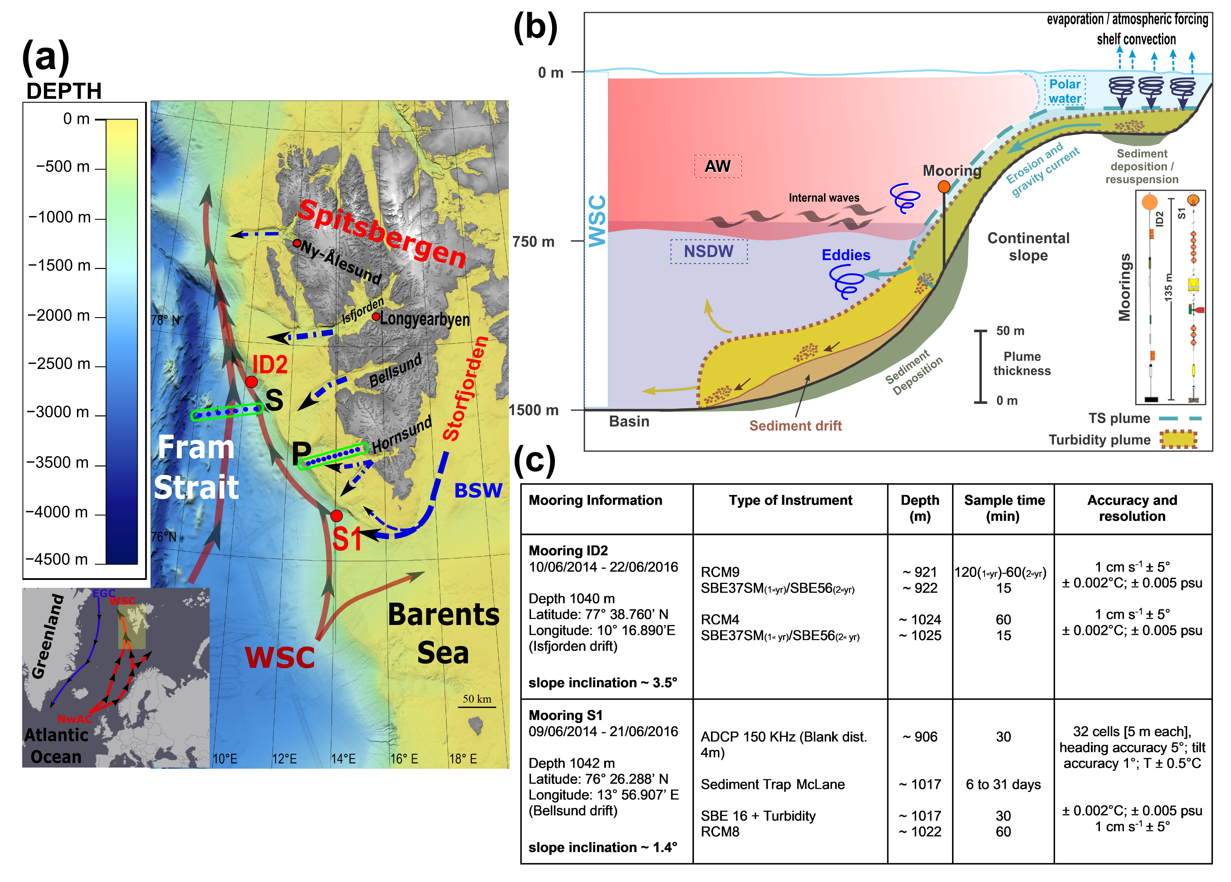
FIGURA 1
-
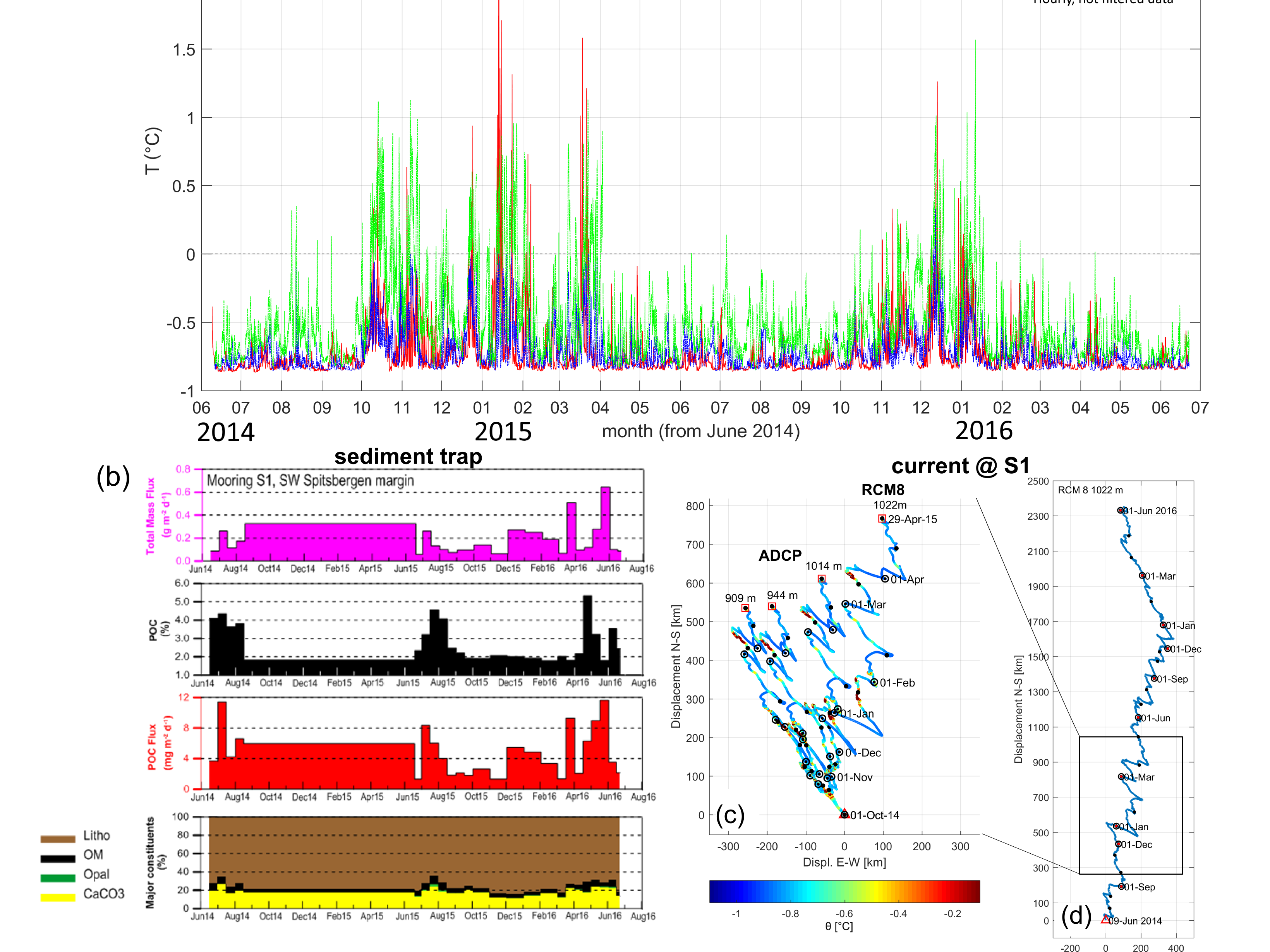
FIGURA 2
-
-
-
- Motivation, importance of research
The southwestern region off Svalbard (Figure 1) is an area where water masses with different properties interact with each other: Atlantic Waters (AWs), warmer than Polar Waters (PWs), flow northward carried by the West Spitsbergen Current (WSC) along the eastern side of the Fram Strait, keeping this region almost ice-free even during the winter season, while cold Arctic waters are carried by the East Greenland Current (EGC) southward along the western side of the strait contributing to the maintenance of the Greenland ice sheet. During winter, dense waters form through ocean-atmosphere interaction and brine release in the polynyas of the Barents Sea and fjords of the Svalbard archipelago, particularly in Storfjorden. Through these dynamics, the export of particulate organic carbon (POC) from the sea surface to the bottom also occurs. It is an essential part of the biological pump. POC from the upper layers is delivered to the deep ocean, which retains carbon dioxide (CO2) for a relatively long time compared to the epipelagic residence time of the same. In recent decades, the Arctic region has attracted international scientific interest as a natural laboratory for studying ongoing climate change, global warming and its effects on ice melt. Since 2002, the decrease in sea ice in the Fram Strait has been significant, as has the gradual increase in water temperature, while particulate organic carbon fluxes have decreased. These oceanic processes, especially the reduction of sea ice and the resulting reduced production of dense waters, have strong implications on the Atlantic Meridional Overturning Circulation (AMOC) and climate. The dense waters flowing down the continental slope west of Svalbard are also responsible for the accumulation of conturites (sedimentary structures affected by bottom currents along the slope), the formation of which coincides with early Pleistocene glacial expansion. The study of these conturites can provide valuable information on the history of ocean circulation and past climate variability. In particular, two conturites have recently been discovered in the area: Isfjorden and Bellsund (Rebesco et al., 2013).
Figure 1 (from Bensi et al., 2019): (a) Map of the study region showing bathymetry (IBCAO) and major currents in Fram Strait and along the western margin of Spitsbergen. Red dots indicate the location of moorings S1 and ID2. Blue dots indicate CTD (conductivity-temperature-depth) stations along the S and P transects. (b) Schematic of processes occurring between shelf and continental slope along the western margin of the Spitsbergen. (c) Schematic of configuration of moorings S1 and ID2. (AW = Atlantic Water; NSDW = Norwegian Sea Deep Water; WSC = West Spitsbergen Current; BSW = Brine-enriched Shelf Water; EGC = East Greenland Current; NwAC = Norwegian Atlantic Current).
- Objectives of the proposal
- Activities carried out and results achieved
As part of the DEFROST project, oceanographic expeditions were carried out in 2016, 2017, and 2018 in order to ensure, first and foremost, annual maintenance of oceanographic moorings and acquire new hydrological data in the study area through CTD (conductivity-temperature-depth) multi-parameter probe casts and biogeochemical sampling. The 2016 campaign, carried out on the German icebreaker ship Polarstern with a dedicated ship time of about 12 hours spent in the study area (southwest off Svalbard Islands) was planned in the project proposal, while the campaigns carried out in 2017 and 2018 on the NATO-owned and operated research ship Alliance were made possible thanks to OGS and CNR's collaboration with the Italian Navy's Hydrographic Institute as part of the multi-year "High-North" program run by the Hydrographic Institute.
Several instruments anchored to the bottom via two oceanographic moorings (S1, ID2; Figure 1) collected data within a layer of water about 150 m thick, at a depth of about 1,000 m, along the southwestern slope off the Svalbard Islands archipelago from June 2014 until June 2016. Subsequently, between June 2016 and July 2018, only mooring S1 was kept in operation, while, given the promising results collected in the first two years of operation, in July 2018, during the High-North 18 campaign, both moorings S1 and ID2 were relocated.
The instruments mounted on mooring S1 (76° 26.288' N; 13° 56. 907' E) between 2014 and 2016 included an ADCP (Acoustic Doppler Current Profiler, Teledyne RD Instruments, Poway, CA, USA) RDI 150 kHz located ~140 m above the seafloor, a CTD (Conductivity-Temperature-Depth) SBE16 (Sea-Bird Electronics, Bellevue, WA, USA) with Seapoint turbidimeter (Seapoint Sensors, Inc, Exeter, NH, USA) coupled with a McLane sediment trap (PARFLUX Mark 78H-21, McLane Res. Labs, East Falmouth, MA, USA) at ~25 m from the bottom, and an Aanderaa current meter (Aanderaa Data Instruments, Bergen, Norway) RCM8 at ~20 m from the bottom. Turbidity, expressed as Formazin Turbidity Unit (FTU), was calibrated in the laboratory to obtain the corresponding suspended sediment concentration values (mg L-1). A dissolved oxygen sensor was also added after 2016. The ID2 mooring (77° 38.760' N; 10° 16.890' E), also between 2014 and 2016, had been equipped with two Aanderaa current meters (RCM9 and RCM4, respectively, ~120 m and ~20 m above the seafloor) and two CT SBE37-MicroCAT recorders below each current sensor (replaced by T SBE56 recorders in June 2015). In July 2018, during the at-sea re-positioning, the ID2 mooring was then further implemented with a sedimentation trap, a CTD equipped with an oxygen sensor, and a current meter equipped with a turbidity meter.
The data recorded by the instruments anchored on the S1 and ID2 moorings were processed after each maintenance and were cleaned and processed according to MyOcean in situ quality control standards and methodology (http://catalogue.myocean.eu.org/static/resources/user_manual/myocean/QUID_INSITU_TS_OBSERVATIONS-v1.0.0.pdf). Time series of temperature, salinity, oxygen and turbidity were also compared with data obtained from CTD casts performed before and after each maintenance.
The acquired data allowed the identification of periodic intrusions of warmer (up to +2°C), saltier (up to ~35), and less dense (up to 27.98 kg m-3) water during the autumn-winter periods, which change the thermohaline properties that characterize deep waters in this region (NSDW, with potential temperature ~ -0.90°C, salinity ~ 34.90, and potential density ~ 28.07 kg m-3). Furthermore, data analysis revealed that these intrusions occur simultaneously at different sites (Figure 2). Indeed, cross-correlation revealed a maximum delay of about 5 hours, despite the distance (~170 km) between S1 and ID2, suggesting that the intrusions of relatively warmer and saltier waters are triggered by internal oscillations of the water column (internal waves driven by topography) whose origin and/or amplification is generated by weather disturbances, typically winter ones, acting synoptically over the entire Svalbard archipelago. Such internal waves propagate with mainly diurnal frequency along the entire western margin of Svalbard. To study the origin of these internal disturbances, we analyzed and compared oceanographic data collected using moorings and meteorological data (wind, surface air temperature, heat fluxes at the air-water interface) collected by the European Center for Medium-Range Weather Forecasts interim reanalysis (ECMWF). These were initially compared with data collected from ground stations (Dirigibile Italia station at Ny-Ålesund, http://www.isac.cnr.it/~radiclim/CCTower/) revealing a correlation greater than 0.84. Then to study significant weather events and the response of the deep sea system, we used the ERA-Interim dataset from ECMWF, whose data are available at 6-hour intervals and cover a regular grid of 0.25° latitude x 0.25° longitude over the entire Svalbard archipelago. Data in the vicinity of sites S1 and ID2 were then extracted from these datasets. Overall, the combined analysis of oceanographic and meteorological data found that the most energetic events occurred consistently in both bottom current flux and wind speed. In particular, increases in current flow at 1000 m depth were observed with a lag of about 1 day (at S1) and 2 days (at ID2) compared to the strong wind events, mainly in the period between October and April. The periodicity of the energy distribution obtained from the "Morlet Wavelet " analysis applied to the wind and current time series was also similar. The interpretation is that the diurnal frequency associated with the variability of the cross-current component (along-shore) may be the result of south-north propagation of topographically trapped waves at 1000 m depth. These internal oscillations stimulate interaction and mixing between the AW and NSDW, resulting in "intrusions" of warmer, saltier water recorded from the S1 and ID2 moorings.
Winter weather disturbances, associated with strong northerly winds, would also seem to be able to occasionally generate the production of dense water, through the cooling of the water column on the continental shelf, capable of moving down the escarpment to depths greater than 900 m, generating the so-called "cascading" phenomenon. The results of these analyses and interpretations are presented in the article by Bensi et al. (2019), to which we refer as a supplement to the information in this project report.
As for the bottom current measurements taken at sites S1 and ID2, the data revealed maximum values of about 60-70 cm s-1. Furthermore, from the analysis of the progressive vector plots obtained from the currents recorded on S1 by ADCP and RCM8 point current meter (Figures 2c and 2d), it can be seen that during the period June 2014 to June 2016, the sub-tidal currents (from which the tidal component is subtracted) were predominantly directed northward, following the bathymetric constraints. It was also observed that the direction of the prevailing current changed slightly with increasing depth and tended to rotate clockwise as it approached the seafloor. Periodic current reversals (in which the prevailing current direction changed from NW to SE) emerged at about 15-day intervals, accompanied by stronger currents, especially during the winter season. In general, the current at site S1 was predominantly NEward between June 2014 and December 2015 (mean u = 0.5 cm s-1, mean v = 4 cm s-1) and NWward between January 2016 and June 2016 (mean u = -0.3 cm s-1, mean v = 3.6 cm s-1). During June 2016-July 2017, the current flow again had N-NE as the prevailing direction.
The sedimentation trap employed on S1 provided data about the total mass fluxes (TMF) allowing to show an inverse correlation of the same with the percentage (%) of particulate organic carbon (POC). It should be noted that in the period August 2014-July 2015 the trap experienced a technical malfunction remaining blocked, as well as in the period June 2016-July 2017. In general, the lithic component related to the material sinking along the water column was the main one and showed maximum values in the winter months. Carbonates were found to be mostly detrital, but in summer they also picked up the biogenic contribution. The peaks of TMF (up to 0.65 g m-2 d-1) were recorded in the late winter-early spring period, while the maximum flux of POC (up to 11.6 mg m-2 d-1) was observed in spring-summer, as a probable consequence of sedimentation of phytoplankton blooms that follow typical seasonal variability at high latitudes. However, some of the POC is also presumably transported by advective or "cascading" processes that occur in late winter-spring in conjunction with the occasional intrusions of warmer, saltier, less dense and more oxygenated water observed in the time series (Figure 2).
The annually integrated POC and total mass fluxes differed by a factor of 3, with the lowest values recorded in the June 2015-June 2016 measurement year (1.6 and 69 g m-2 y-1, for POC and TMS, respectively) and the highest values recorded in July 2017-July 2018 (5.9 and 177 g m-2 y-1, respectively), with no apparent relationship to the variability associated with water mass characteristics (temperature and salinity). In contrast, hydrodynamics seems to play a greater role in the input of material from the shelf margin. In fact, during July 2017-July 2018, the year with the highest particulate fluxes, the direction of the currents showed the highest value of the down-slope component.
Figure 2: (a) comparison of time series of temperature (°C) recorded on mooring S1 and on mooring ID2 in the period 2014-2016 where the contemporaneity of temperature peaks at the two measurement sites can be seen; (b) data recorded on the sedimentation trap on mooring S1; (c-d) progressive vector plots obtained from currents recorded on S1 by ADCP and RCM8 point current meter (Bensi et al., 2019).
Currents from ADCP to hull (vmADCP).
Complementing the current measurements collected from moorings, this section presents the main results for current measurements made by hull current meter in the first 300-500 m of the water column during two oceanographic campaigns, in summer 2016 (PS99-DEFROST, n/r Polarstern) and 2017 (HN17, n/r Alliance). Measurements were made with an RDI ADCP model vertical current profiler (vessel mounted Acoustic Doppler Current Profiler, vmADCP), capable of emitting an acoustic signal at frequencies of 150 kHz (PS99, 2016) and 75 kHz (HN17, 2017).
During the 2016 campaign, measurements in the study area were carried out from 21/06 3 p.m. UTC until 23/06 2 a.m. UTC, along a SW-NE transect of about 25 km passing over station S1, between the bathymetrics of 250 m and 1250 m, and along a similar transect of about 70 km passing over site ID2, between the bathymetrics of 1300 m and 50 m, data from which were also collected while sailing to Longyearbyen. Current measurements were also recorded along the transect that covered the distance between moorings S1 and ID2. Data were averaged over a 20-minute time interval in a layer between 23 m and 300 m depth with a vertical resolution of 4 m. A total of 110 vertical profiles were recorded, of which 30 relate to the approach route between the two moorings. In the area of S1, measurements showed that current intensity and direction were rather constant at depths greater than 50 m, revealing barotropic behavior in the water column. The current velocity varied between 10 and 20 cm/s while the prevailing direction was NW, thus aligned according to the orientation of the isobaths. Velocity values between 20 and 30 cm/s and direction similar to that observed at station S1 were recorded in the ID2 area.
During the HN17 campaign (July 2017), similar measurements were made in the area of S1, along a 35-km-long SW-NE transect (between the 200 m and 1250 m bathymetrics) and around the southern tip of Svalbard to the entrance of Storfjorden, between 21/07 6:40 UTC and 23/07 06:12 UTC. Approximately 180 averaged current profiles were collected every 15 minutes in a layer between 28 m and 550 m depth, with a vertical resolution of 16 m. I particular, about 48 profiles were made in the area around S1 (on 21/07 and 22/07) from which it was found that the current velocity ranged from 10 to 40 cm/s. The prevailing direction of the flow was NW, although changes in direction toward the E (east) were temporarily observed. In the area of the continental slope, on a seafloor between 400 and 600 m depth, currents of greater intensity were measured in the deep layers than those measured in the shallower layer, aligned with the isobaths and directed NW. In contrast, currents with a predominantly E direction were measured on the continental shelf.
At the entrance of Storfjorden, along the 400-m isobath, a relatively strong NE-directed current flow was recorded, with velocities between 30 and 50 cm/s, decreasing from the surface toward the bottom. The Storfjorden inlet is strongly influenced by the tide and thus by high temporal and spatial variability (at scales of several km) of the measured currents.
In conclusion, the measurements obtained from the vmADCP in the area of the moorings revealed the presence of a NW-directed current flow, which can be associated with the prevailing direction of the West Spitsbergen Current carrying Atlantic Water. Intensification of the flow near the bottom of the continental slope was also observed, as well as great spatial variability in the intensity of the currents, which can be locally attributed to the effect of tides and the effect of seafloor morphology, especially near the continental slope.
Physical and biochemical characterization of water masses.
In order to identify the signal given by the presence of dense water in the shelf and continental slope areas west of Svalbard, hydrological measurements were complemented by the collection of water samples intended for the analysis of the main biogeochemical parameters whose distribution, along the water column, can provide useful information to estimate the age and origin of different water masses.
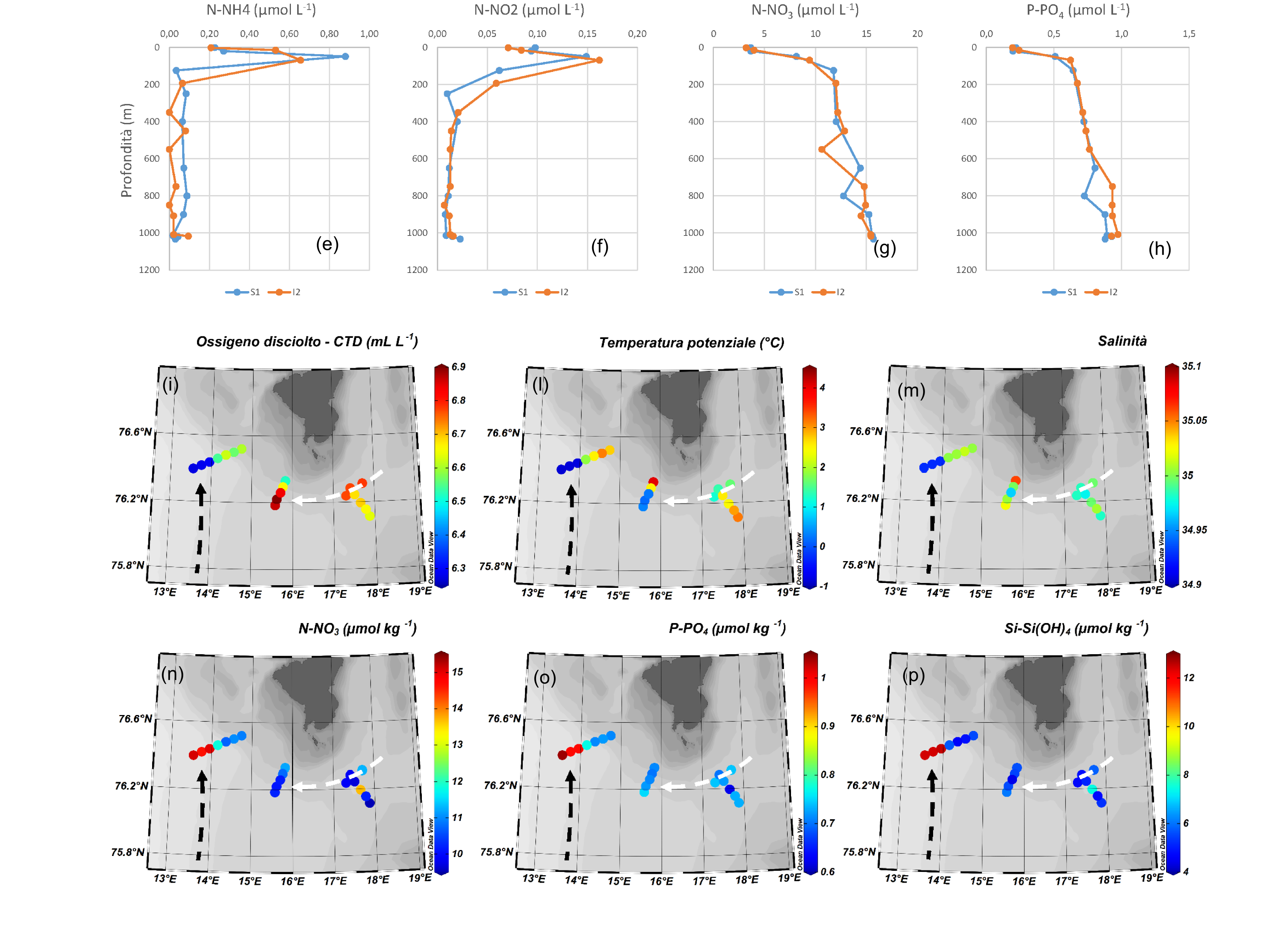
plus from SeaBird Electronics equipped with temperature, conductivity, oxygen, fluorescence, transmittance and altimeter sensors. A Carousel equipped with 24 Niskin bottles of 12 L each (2016 campaign), or 12 Niskin bottles of 5 L each (2017 campaign), was used to take water samples at the various altitudes, which were identified based on the examination of the vertical profile acquired through the CTD. Determination of dissolved oxygen was carried out on board according to the Winkler method, while samples intended for analysis of inorganic nutrients (ammonium, nitrite, nitrate, phosphate, and silicates, 2016 and 2017 campaigns), and other parameters characterizing the carbonate system (Dissolved Inorganic Carbon - DIC, pH, and total alkalinity, 2016 campaign only) were appropriately processed and stored for subsequent analysis performed at the OGS chemistry laboratories. Biogeochemical analyses performed on the samples collected in 2016, at the deployment of the S1 and ID2 moorings, showed significant differences between the more superficial versus deeper waters at both sites (Figure 3a-h). Indeed, surface waters (above 100 meters depth) were found to be generally more oxygenated and characterized by higher pH and total alkalinity values. At sub-surface elevations (50/70 meters), moreover, ammonium and nitrite concentrations were found to be 20 to 30 times higher than at bottom elevations indicating the presence of relatively young waters. This assumption is supported by the fact that at the surface there is a general depletion in terms of silicates, nitrates and phosphates.
Below 100 meters, the vertical profiles, of all the parameters investigated, were found to be relatively homogeneous and similar to each other at the two sites. The exception was silicates, for which a slight positive concentration gradient was noted as depth increased, with maximum values reached near the bottom (∼1000 m).
The distribution of nutrients, in the bottom waters of the three transects investigated in 2017 southwest of Storfjorden, can be related to that of physical parameters such as potential temperature, salinity and dissolved oxygen. Two main water masses have been identified in the investigated area (Figure 3i-p): one, relatively warmer, oxygenated and characterized by higher salinity and low nitrate, phosphate and silicate content, the presence of which can be associated with a probable transit of the Brine-Enriched Shelf Waters (BSW); the other deeper and colder, characterized by lower salinity values and higher inorganic nutrient concentrations associated instead with the transit of the Norwegian Sea Deep Water (NSDW).
Figure 3: (a-h) Vertical profiles of pH and concentration of total alkalinity (TA), dissolved oxygen (DO), silicates (Si-Si(OH)4), ammonium (N-NH4), nitrite (N-NO2), nitrate (N-NO3), and phosphate (P-PO4) at sites S1 and ID2; (i-p) Distribution of dissolved oxygen, potential temperature, salinity, nitrate, phosphate, and silicate in the bottom waters of transects investigated during the High North 2017 campaign southwest of Storfjorden. Black and white dashed arrows indicate the path followed by Brine-enriched shelf waters and Norwegian Sea Deep Water, respectively.
Geological Data
Geological data were collected over 5 years during as many campaigns under different research projects, including the DEFROST project: in the PREPARED campaign (2014, R/V G.O. Sars) geophysical data, such as multi-beam and sub-bottom (Topas), and sedimentological data, such as sediment cores in the areas of the moorings, were acquired; in the EDIPO campaign (2015, R/V OGS Explora) new geophysical data (reflection seismic) were acquired and previous datasets (multi-beam and sub-bottom acquired during the PREPARED campaign) were expanded, focusing particularly in the area of the Isfjorden drift; in the PS99/BURSTER/DEFROST campaign (2016, R/V Polarstern), geological data were acquired on bottom current-controlled structures in areas adjacent to the moorings; in the High-North17 campaign (2017, R/V Alliance) geological data were acquired related to structures controlled by bottom currents, focusing in the diversification between along-slope and down-slope structures, in the areas of the moorings and the area south of the Kveithola TMF; in the High-North18 campaign (2018, R/V Alliance) geological data were acquired related to structures controlled by bottom currents in the area of the Isfjorden drift.
Using the collected data, the morphology and lithology of the seafloor, as well as the internal geometries and lithological variations within the sediment drift were analyzed. Analysis of the collected data showed that sedimentation in this margin area is controlled by along-slope bottom-currents, which are characterized by a relatively low velocity that varies at different time scales (Rui et al., 2019). Sedimentary input to the bottom-currents is also assumed to come from along-slope waterfall phenomena along the continental slope, i.e., sediment transport through the cascading of dense water obtained from sea ice formation.
- Products
- Oceanographic data collected through the use of moorings during 2014-2016 were entered into the National Oceanographic Data Center (NODC) and available on the Seadatanet portal.
The data and work done as part of the PNRA DEFROST project also served to obtain additional funding that was useful for the science team to contribute to the first annual report of "The State of Environmental Science in Svalbard," published by Svalbard Integrated Arctic Earth Observing System (SIOS) consortium in January 2019 (https://sios-svalbard.org/sites/sios-svalbard.org/files/common/SESSreport_2018_FullReport.pdf).
The DEFROST project has also allowed to strengthen collaborations with Italian (Hydrografico della Marina, Università Ca' Foscari, Venezia) and international (AWI, IOPAN, UNIS, UGOT, CMRE) partners, fostering future developments regarding Italian activities in the Arctic.
Finally, since 2018, OGS has become a member of ArcticROOS (Arctic Regional Ocean Observing System), promoting and enhancing the time series collected through the S1 and ID2 moorings.
- Oceanographic data collected through the use of moorings during 2014-2016 were entered into the National Oceanographic Data Center (NODC) and available on the Seadatanet portal.